
Every Sunday, I give myself a little challenge and go on a walk or trek. In 2018, so far this has included the Southern Walkway in Wellington, Manawatu Gorge, Turakirae Head, and Waikanae Riverbank (all quite different walks, and all recommended. Also suggest Central Park in Brooklyn/Te Aro and Otari-Wilton’s Bush, both in Wellington).
Last Sunday, I discovered the Parata Walking Track at Hemi Matenga Scenic Reserve in Waikanae.
The Reserve ticks so many boxes, with three walks to choose from depending on your time available and fitness level. Plus, it gets bonus points for being dog friendly to pups on leads!
There’s the Kohekohe Walk (30 mins), Parata Walking Track (1-2 hours), and Te Au Track (3-4 hours).

I lived in Kapiti for two years, yet never knew about this track. It’s amazing what you can find when you actually start looking.
When driving through Waikanae, turn at the lights and go over the railway tracks east, and follow the signs to Tui Crescent.
You can park on the street and then walk up what looks like a giant driveway (look back at the top and there’s a great view of Kapiti Island. The residents in this street have a stellar outlook). You’ll then see a path entrance to the left and one of the prettiest short walks to the intersection of Parata and Kohekohe.
It really is beautiful. Not unlike a lot of NZ scenery, you can get lost in the magic of it. There are streams, twisted trees, outstretched branches, and even a bridge.


However, this was a tougher walk than I had expected. Now, I can make excuses that it was a very hot day and that I had already done a short walk at Scotts Ferry only a few hours earlier, but it was still a burn on the calves after this point.
I was tired within about fifteen minutes! The path just goes straight up, and I had to stop at least a couple of dozen times and turn around so my toes pointed back down the hill so as to give my calves a bit of a rest.
There were families and pets happily – practically skipping! – down the path on the return trip, so I was shaking my head in disbelief at how tired I was going up.
Disclaimer: You will likely find it easier than me. Unknown to me at the time I was starting a week (well, it’s a week so far, ongoing as I type) of fatigue.
But overall this was an energising tiredness. At no point did it even cross my mind to turn back. I knew from my research that it was around an hour to the top, which possibly helped with my focus. Knowing how much further you’ve got to go does enable you to keep pushing forward. But… it feel like it was more than that. There’s something about the surrounding nature of Parata that makes you want to keep going.
Signs at the entrance said there was a lookout at the top, and once out of the trees I came across a couple of beautiful spots. The first, where if you stepped off the path and onto a mound to look back over the trees, you are shown a view of Kapiti Island. Just around the corner is a seat and an impressive panoramic of the Reikorangi Valley.


But here’s the thing: there’s no sign to tell you “this is it”, you know, “you’ve reached the top”. I knew that where the Parata track ended, the Te Au Track began. So I assumed that if this was the top, there would be a sign pointing in both directions with the track names and expected times they’d take to complete.
But there was nothing.
So what did I do? I kept going. I accidentally started on the Te Au Track.
It takes you up an overgrown path along the fence line of private property. This is the only moment I thought it would be nice to be wearing tights instead of shorts as the grass tickled my legs.
At the end of that path you turn in left and return to bush. Here though, the path is far less obvious. At times you have to look for markers to confirm you’re on the right track. I realised here that I had likely gone past the end of Parata but was not completely convinced. I think I wanted a better lookout to be honest!
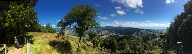
And so I journeyed about another fifteen minutes from the lookout with the seat, and discovered one of the best views in Kapiti.


Just being this little bit higher up from the earlier view, transforms Kapiti Island. You can see for miles and it really is breath-taking. No amount of pictures on my iPhone can relay how beautiful this spot is, the way the water shimmers in the sun, the sprawl of the town, the sparkle on the horizon.
I lost track of time at the top. It was at least ten minutes. Possibly twenty. I could have stayed there all day.
It was only as I went to continue on my journey that I realised fully that I had strayed from the Parata Walking Track. A quick Google brought up the Department of Conservation’s map of the area. And a comparison on my FitBit map confirmed my location.


I considered continuing on, but a few factors stopped me: not knowing for sure how long it would take until exit, and then again how long to return to my car… the fact that it was after 5pm and I my mind was already on food… and that I wanted to travel down the Parata track, not just up.
So I turned back the way I came and quickly found myself at the fenceline, then the proper lookout, and then again into the bush. From here, it was exceedingly enjoyable as you can easily run/jog down the hill.
At times I was probably more Phoebe Buffet than John Walker in my running style, but it was so fun on the return trip. Well worth the walk up, although I’d already been paid in kind with the incredible scenery.
I spoke to a few people on the way down. Some who were relieved to hear the top was drawing near, others who wanted to compare times, and a few who chatted happily about the pets travelling with them.
I took my time to stop and take photos both on the way up and down, and spent around two hours in total in Waikanae.
I was exhausted at the end, but in a good way. It’s definitely a walk I’ll do again. I recommend going the extra fifteen minutes or so to the Te Au lookout, but even if you just go to the top of the Parata Walking Track, you won’t regret it.
As always, remember to tell someone where you’re going and when to expect you back. Take a charged phone, water, and sturdy walking shoes or hiking boots. Respect nature and the path, and while it’s a beautiful spot, you must look where your feet are going.

It might have felt like a walk of hell on the way up, but ultimately it was a “hell, yes” – and if you’re after a beautiful trek uphill, definitely give it a go.
If you have other walks you’d recommend in the wider Wellington region, or want to share your favourite, comment below.
Some of my faves include Mt Kaukau, Colonial Knob, Red Rocks, and Mt Victoria. Kapiti Island is on my to-do list!

Leave a comment